Skip to content
NOWCAST WLKY News at 9:00am
Watch on Demand
Advertisement

Belski's Blog - Limited tornado risk for Friday

from the remnants of Hurricane Laura

.
.
.
SOURCE: .
Advertisement
Belski's Blog - Limited tornado risk for Friday

from the remnants of Hurricane Laura

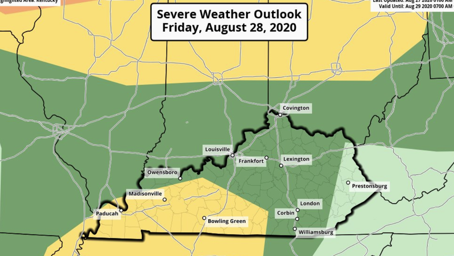
Updated late afternoon, Thursday, August 27......The remnants of Hurricane Laura will be moving through the Ohio Valley Friday and Friday night.The heaviest rains are forecast to fall south of Louisville.==There is a Slight Risk for excessive rain for the Louisville area.==Louisville will be between the main action from Laura to the south and an advancing cold front to the north.By early afternoon, Laura will enter western Kentucky.By evening there will be widespread rain and storms in the area.The Storm Prediction Center has a risk of severe storms over a wide area for Friday.The front to the north will have widespread thunderstorms.Laura coming in from the southwest will have widespread rain and some storms.The dark green is a MARGINAL RISK or level 1 for severe storms which covers most of the WLKY viewing area.The yellow area is a SLIGHT RISK or level 2 and that covers.....Rough River LakeLeitchfieldNolin LakeMunfordvilleGreensburgCampbellsville==TORNADO RISKMost of the WLKY viewing area is in a 2% risk for a spin up tornado with the tropical remnants. There is a 5% risk across southern Kentucky and these areas south of Louisville.Rough River LakeLeitchfieldNolin LakeMunfordvilleGreensburgCampbellsville==DAMAGING WINDSThe entire WLKY viewing area is in a 5% risk for damaging winds.==This type of tropical system can produce the tornadoes with little or no lightning. Keep up on weather conditions, especially Friday evening, for the potential for severe storms.I will have another update in the morning.

Updated late afternoon, Thursday, August 27......

The remnants of Hurricane Laura will be moving through the Ohio Valley Friday and Friday night.

Advertisement

The heaviest rains are forecast to fall south of Louisville.

.
Rain totals into Saturday

==

There is a Slight Risk for excessive rain for the Louisville area.

.
Flash Flood risk for Friday

==

Louisville will be between the main action from Laura to the south and an advancing cold front to the north.

By early afternoon, Laura will enter western Kentucky.

.
2:00 PM Friday

By evening there will be widespread rain and storms in the area.

.
8:00 PM Friday forecast

The Storm Prediction Center has a risk of severe storms over a wide area for Friday.

.
.

The front to the north will have widespread thunderstorms.
Laura coming in from the southwest will have widespread rain and some storms.

.
.

The dark green is a MARGINAL RISK or level 1 for severe storms which covers most of the WLKY viewing area.
The yellow area is a SLIGHT RISK or level 2 and that covers.....
Rough River Lake
Leitchfield
Nolin Lake
Munfordville
Greensburg
Campbellsville

==

TORNADO RISK

.
Tornado risk for Friday

Most of the WLKY viewing area is in a 2% risk for a spin up tornado with the tropical remnants. There is a 5% risk across southern Kentucky and these areas south of Louisville.
Rough River Lake
Leitchfield
Nolin Lake
Munfordville
Greensburg
Campbellsville

==

DAMAGING WINDS

.
damaging wind risk for Friday

The entire WLKY viewing area is in a 5% risk for damaging winds.

==

This type of tropical system can produce the tornadoes with little or no lightning. Keep up on weather conditions, especially Friday evening, for the potential for severe storms.

I will have another update in the morning.